
We are so excited for our next stop – Yosemite National Park. Stunning sheer granite walls, meandering rivers and iconic landscapes. We are camping in the park at Lower Pines Campground in the heart of the park – we feel very lucky to have the reservation. There are only a couple spots that our 30-foot Airstream will fit in – we were so happy to get one of them by booking the instant reservations open online five months in advance! We also are relieved that the park is open – it has been closed due to forest fires for weeks and just opened a week and a half before we are scheduled to arrive. We are also concerned about smoke – we are hoping that the park and campground will be clear!


We enter from the south on Highway 41 by the Wawona Road Entrance. Fresh burn areas, ash on the ground, blackened trunks and a slight haze of smoke hangs in the air when we drive in. We even see some trees still smoking. Wawona Road is pretty but it is a cliff road with big drop offs – we are glad we are on the inside. It will be a bit of a nail biter on the way out. As we drive into the stunning Yosemite Valley, the haze of smoke really has cleared and we are excited to see El Capitan and Half Dome. We arrive at Lower Pines Campground, which is also completely smoke-free. We back into our spot, which has some trees, but the sun will hit our solar panels all day – a great site for dry camping. Since there are no hookups, set up is easy. We were warned about bears when we pulled in and there are bear signs posted everywhere, but camping in a tin can has its benefits! The campground is right on the Merced River and we have views of sheer granite walls. Beautiful.


On the afternoon of our arrival we follow our usual routine of going to the Visitor Center to stamp our passport, watch the park documentary and request Elle’s junior ranger book.

The following morning we hike up to Vernal Falls, well almost all the way. Elle is usually a good hiker but she insists she is tired of hiking and refuses to go the last quarter mile, so we just view the falls from the trail and turn back. This is one of the busiest trails we have been on the trip – this park is popular. And we hear languages from around the world. Yosemite attracts a lot of international visitors. On the way down we see a group of people clustered on the trail looking down at the Merced river. A bear! Our first Yosemite bear! It is a black bear moving quite rapidly along the banks of the river. The people down by the river catch sight of him and quickly move out of the area – we have never seen a group of hikers move so quickly! That night we decide to splurge for dinner at the Majestic Lodge. The lodge is beautiful – huge stone rooms, we feel like we were in a National Park Lodge. Dinner, however, is expensive and the food is simply mediocre. But it was a beautiful setting to spend an evening.


The next day we tackle the Columbia Rock hike. It’s only 1.5 miles up with, but with 1,000 feet of elevation gain, it’s a steep hike. We take the park shuttle to the trailhead for the Upper Yosemite Falls. The Columbia Rock hike is simply the lower section of the Upper Falls trail. The unshaded parts of the trail are very warm – it’s a sunny day. And the trail is difficult, but we make it to Columbia Rock and our reward is stunning views along Yosemite Valley from Half Dome in the east to Cathedral Spires in the west.


Coming down the trail is difficult – it’s steep and there is a lot of sand and scree. Our legs are really tired and a bit sore when we finally get down. This has been our hardest hike to date. We shuttle back to the campground and have a quick lunch before dashing over to the Nature Center for the Children’s Art program, only to find it canceled when we arrive. Time to go back to the Airstream to rest! That night we attend one of the children’s programs at Half Dome Village and Elle has fun playing with the other kids.
Our final day in the park we drive out to the Mariposa Grove of giant sequoias near the south entrance of the park (where we came in) and, on the way back to the Valley, stop to hike the very short Bridal Veil Falls trail… more like a short, paved stroll, but well worth it nevertheless.


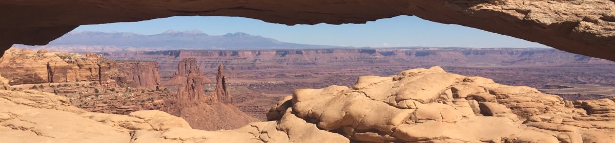
Since we have now hit all the high elevation national parks in California that can be hard to visit when we will come back to California in November, it is time for us to head back west to the heart of the Rockies and the high plateau states before winter sets in – our plan is to head across Nevada to Great Basin NP and then hit all of Colorado before heading back across Utah, culminating with a visit to the Grand Canyon. Stay tuned . . .