Every adventurer has a moment when a landscape calls their name. Sometimes it’s a distant ridgeline glowing at sunset. Other times, it’s something deeper — a sound, a vibration that whispers, “You haven’t really been here until you’ve gone farther than most would dare.”
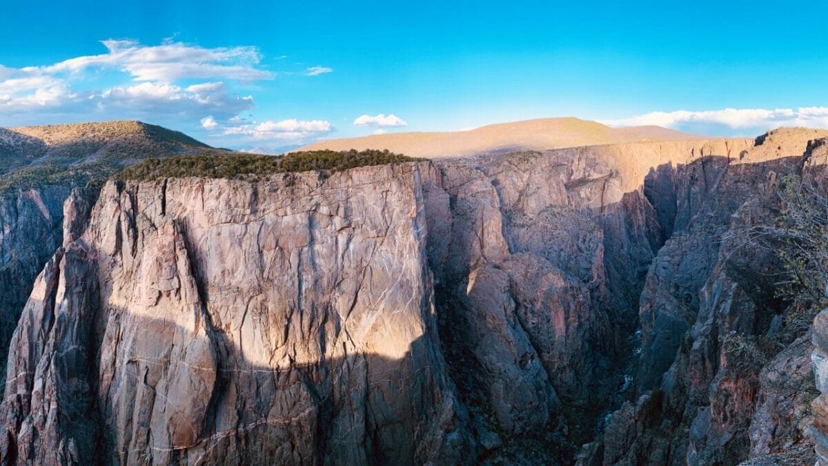
For a rare few, that moment happens at Black Canyon of the Gunnison National Park. Standing on the rim, the world looks carved open — a cathedral of stone and silence. Most people stop there. They take their photos, admire the view, and drive away satisfied. But if you’re reading this, you already know you’re not “most people.”
You want to feel the river that shaped this impossible gorge. You want to earn the view from the bottom up. And you’re ready for a story written in sweat, grit, and awe.
The first thing you notice isn’t the view. It’s the sound.
From the paved overlooks of the South Rim, you can stand at a guardrail and look down — down, down, down — into a chasm so deep and sheer it almost seems unreal. But you can’t just see the Black Canyon. You hear it.
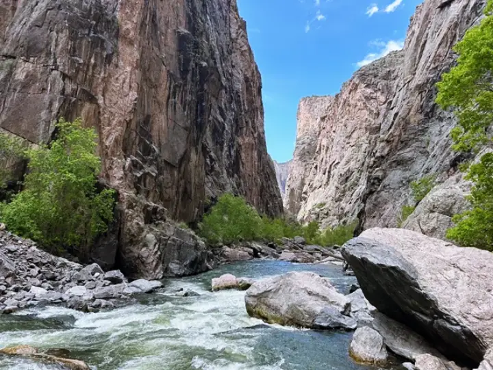
Faintly, from 2,000 feet below, comes the constant, muffled roar of the Gunnison River — a sound that reminds you that the real park isn’t up here. It’s down there.
🏞️ This is a place of dizzying verticality. Carved by the river over two million years, its walls are so steep that sunlight only touches the bottom for minutes a day, leaving the depths in perpetual “black” shadow.
Ninety-nine percent of visitors experience this park from their car, snapping photos from viewpoints — and that’s fine. But this guide isn’t for them.
This guide is for the one percent who hear that river and feel an undeniable pull to answer it. It’s for the experienced hiker, the scrambler, and the thrill-seeker who wants to earn their view from the bottom up.
These aren’t trails. They’re challenges — raw, unmaintained routes that demand respect and preparation.
If you’ve ever dreamed of experiencing the unfiltered heart of Black Canyon, this is how to do it — and how to live to tell the story.
How to Explore Inside the Black Canyon
This isn’t hiking. It’s route-finding in a vertical wilderness.
Exploring the inner canyon is not a casual walk; it’s a test of nerve and navigation in one of the steepest places in North America. Failure to prepare isn’t just risky — it can be fatal.
⚠️ The Unforgiving Rules: Your Wilderness Use Permit
Before taking a single step below the rim, you must have a Wilderness Use Permit. No exceptions.
How to Get One:
Permits are free and issued in person only. You can’t reserve them online or by phone.
Where & When:
- South Rim: Available at the Visitor Center for same-day use starting 8 a.m., or for next-day trips after 3 p.m.
- North Rim: Pick up at the Ranger Station (hours vary).
Why It Matters:
A ranger will check your plan and gear, making sure you have the “Ten Essentials.” They can deny your permit if you’re unprepared — and that’s not bureaucracy; that’s life-saving caution.
📎 Check current rules on the official NPS Inner Canyon page.
The Reality of the “Trail”
These descents drop nearly 2,000 vertical feet per mile — that’s twice as steep as most mountain switchbacks.
- Terrain: Loose rock, slick scree, thorny oak, and sudden drop-offs.
- Poison Ivy: Covers the canyon floor. Long pants and gloves aren’t optional.
- The Climb Out: The descent taxes your knees; the climb breaks your lungs. Expect 1.5 hours down and 3–4 hours up.
- Navigation: Cairns and intuition are your only guides.
This isn’t meant to scare you — it’s to prepare you. Because if you’re ready, the reward is pure solitude and the raw, humbling beauty few on Earth ever feel.
⭐ Featured Routes: The 5 Paths to the River
There’s a point where the overlook railings end and the silence begins.
From there, five faint lines snake toward the Gunnison — each one a whisper in stone, a dare to go deeper.
These aren’t trails. They’re stories.
And each one has its own mood, rhythm, and reward.
| Route | Rim | Character | Distance (One Way) | Elevation Drop | Defining Moment |
|---|---|---|---|---|---|
| Gunnison Route | South | Gateway route — steep but defined | 1 mi (1.6 km) | 1,800 ft (549 m) | The 80-foot chain |
| SOB Draw | South | Short, savage, pure gravity | 0.75 mi (1.2 km) | 1,800 ft (549 m) | The “bowling alley” scree field |
| Tomichi Route | South | Wild maze through dense brush | 1 mi (1.6 km) | 1,800 ft (549 m) | Breaking through the oaks to daylight |
| Long Draw | North | Solitude and silence, pure wilderness | 1 mi (1.6 km) | 1,800 ft (549 m) | Touching the river alone |
| Slide Draw | North | The canyon’s most dangerous descent | 0.75 mi (1.2 km) | 1,800 ft (549 m) | Rockfall echoing from above |
1️⃣ The Gunnison Route — The Gateway Descent
If you only tackle one route into the Black Canyon, make it this one.
It starts gently, as if trying to lull you into confidence — a leafy path through oak and sage where sunlight filters gold through the branches. But a few hundred yards in, the earth simply drops. The air cools, the walls close in, and the Gunnison’s voice grows louder with every cautious step.
Trailhead: South Rim Visitor Center
Best For: Experienced hikers testing the inner canyon for the first time.
The Challenge: Scrambling over loose rock and gripping an 80-foot assist chain anchored in stone.
The Moment:
You reach the chain. It gleams in the dim light, cold and solid. Your heartbeat syncs with the river’s roar far below. Every link you descend feels like crossing a threshold — from tourist to explorer.
Pro Tip: Expect a few anglers at the bottom, quietly casting into dark, swirling pools. Otherwise, you’ll have the canyon to yourself.
2️⃣ SOB Draw — The Shortest, Steepest Lesson in Humility
There’s no easing into this one. The route practically falls away beneath your boots.
Within minutes, you’re surrounded by sheer walls of scree — unstable, shifting ground that feels alive. Every rock you step on slides, clatters, and tumbles ahead, disappearing into the void below.
Trailhead: Near South Rim Campground (Loop C)
The Challenge: Steep scree chute nicknamed “the bowling alley.”
Difficulty: Officially “extremely strenuous.” In reality? Brutal.
The Moment:
You stop, brace your hand against a boulder, and watch as the canyon swallows your echo. The silence is total — the kind that humbles even seasoned mountaineers.
Traveler Insight: Gloves are your best friend here, and a helmet is non-negotiable. A fall might only be ten feet — but ten feet here can mean the difference between “story” and “rescue.”
3️⃣ Tomichi Route — The Lost Trail Through Living Brush
Some routes test your strength. This one tests your patience.
The Tomichi Route is less of a trail and more of a labyrinth. Scrub oak closes in overhead, trails splinter into animal paths, and GPS signals fade. You push through brush taller than your head, branches catching your pack straps, until suddenly — light.
Trailhead: Tomichi Point Overlook
The Challenge: Constant route-finding and thick vegetation.
Mood: Confusing, claustrophobic, then suddenly liberating.
The Moment:
You burst from the oak tangle onto an open spine of rock. The canyon unfolds before you — a cathedral of granite and sky. You breathe deep, dirt under your nails, and realize you’ve just earned one of Colorado’s purest views.
Pro Tip: Don’t even think about going without offline maps on Gaia GPS. It’s not optional; it’s survival.
4️⃣ Long Draw — Where Silence Becomes a Sound
On the North Rim, the world feels different — lonelier, wilder, closer to the edge of something ancient.
Long Draw drops into that silence like a dream. The route is faint, the rock loose, the reward absolute. There are no other hikers here. Only wind. Ravens. And your own breath against the rhythm of gravity.
Trailhead: Near North Rim Ranger Station
The Challenge: Steep, remote, with no margin for error.
Best For: Skilled adventurers craving solitude.
The Moment:
You step onto the riverbank. Water explodes white against stone, echoing through the gorge like thunder trapped in a bottle. You sit on a sun-warmed boulder and feel it — the pulse of the earth, right beneath your boots.
Traveler Insight: Rescue here is distant, sometimes days away. Bring extra food, layers, and a first-aid kit that would make a ranger proud.
5️⃣ Slide Draw — The Canyon’s Final Test
If the Black Canyon had a dare, it would be this.
“Slide” is not a poetic name. It’s a warning. The chute is a moving river of loose rock, constantly rearranging itself. The sound of small stones cascading around you never stops — a quiet, metallic rain. Helmets aren’t just recommended; they’re survival gear.
Trailhead: North Rim Ranger Station
The Challenge: Active rockfall and extreme exposure.
Mood: Fear, focus, and transcendence.
The Moment:
There’s a stretch where the walls narrow and the footing disintegrates. One wrong step would mean freefall. You move with monk-like precision, every sense heightened, every breath deliberate. And when you finally reach the river, adrenaline dissolves into laughter — the wild, relieved kind that only comes from flirting with your limits.
Pro Tip: Pick up a solid climbing helmet at the REI Outlet. It’s one of those purchases you hope you never need to prove was worth it.

⚡ The Truth About All Five
Every route here carries the same elevation loss — roughly 1,800 feet in a mile — and the same message: you don’t conquer the Black Canyon; you negotiate with it.
The rock decides.
The river decides.
You just show up prepared — mind clear, gear ready, heart open.
When you climb back to the rim and look down again, you won’t just see a canyon anymore.
You’ll see a memory carved in muscle and breath — proof that you answered when adventure called your name.
Traveler Tip Box: Your Inner Canyon Permit
When to Go:
Summer brings long light but punishing heat. Go early. Spring runoff can make the river dangerous, while fall offers perfect clarity and fewer crowds.
Permit Strategy:
Arrive before the Visitor Center opens to secure a spot, or line up at 3 p.m. the day before.
The Ranger Chat:
Be honest about your skills. Rangers aren’t gatekeepers — they’re guardians. Their advice on route conditions could save your life.
Adventure Planning Essentials
🚐 Your Basecamp: Camping & RVs
Whether you crave solitude or comfort, basecamp matters.
- South Rim Campground: Convenient and reservable — wake up steps from the Visitor Center so you can grab a permit first thing. Book early on Recreation.gov.
- North Rim Campground: Primitive, remote, and first-come first-served — for those who want to hear coyotes more than people.
If both are full, you still have options.
RV Life: Turn your trip into a week-long road story with RVshare. You’ll have a bed, kitchen, and total freedom to chase canyon light across Colorado.
Private Stays: Prefer hot showers and starry skies? Find hidden cabins, yurts, and glamping tents near the park through Hipcamp. After a day clawing up 2,000 feet of rock, a real bed feels heavenly.
🎒 The “Sanity Check” Adventures
Not ready for the inner canyon? Or need a rest day before the drive home?
- Deadhorse Trail (North Rim): Five miles roundtrip, unmarked but rewarding. You’ll see the famed Curecanti Needle and enjoy North Rim solitude without the risk.
- Ute Trail (South Rim): A calm two-mile walk through pinyon and juniper forest leading to ancient petroglyphs — history beneath the same cliffs you just climbed.
🚶♂️ The Guided Option: Explore Without the Risk
If you crave epic landscapes but not the danger, let a guide handle the logistics.
You can join an incredible 7-Day National Parks Tour from Denver — covering Black Canyon, Canyonlands, Arches, and more.
✅ Includes park entry, transportation, and expert guides.
✅ Effortless adventure — zero planning, maximum immersion.
You can book this exact experience through GetYourGuide. It’s the easiest way to step into wild places safely — and still feel every ounce of wonder.
🧭 Essential Gear for the Inner Canyon
This isn’t a “Ten Essentials” list — it’s what could literally make or break your trip.
| Gear Type | Why It Matters | Where to Find It |
|---|---|---|
| Navigation | A downloaded offline map on Gaia GPS — because cell signal dies halfway down. | Gaia GPS App |
| Traction | Sturdy hiking boots or approach shoes with aggressive tread. Trail runners = regret. | REI Outlet |
| Hand Protection | Gloves protect against rock abrasion, the 80-foot chain, and poison ivy. | Amazon |
| Head Protection | Lightweight climbing helmet — essential for SOB & Slide Draw. | REI Outlet |
| Hydration | 3-liter reservoir; you’ll need 3–4 liters per person. | Amazon |
| Leg Protection | Long pants only; poison ivy and thorns are brutal. | REI |
| First Aid | Full kit with blister care & tape for sprains. | REI |
| Light | A headlamp — even a short injury can mean a night in the canyon. | REI Outlet |
💡 Pro Tip: Start at the REI Outlet to grab past-season gear — helmets, gloves, and packs often cost 40–60 % less, with the same trusted quality.
Wrap-Up: Travel Smarter, Feel Deeper
The Black Canyon of the Gunnison doesn’t coddle anyone. It doesn’t hand out easy views or tidy paths. It asks a simple, haunting question:
“Are you content with the view, or do you need to earn it?”
Most will take the overlook. But a few — maybe you — will shoulder a pack, grip that chain, and descend toward the sound that called you from the rim.
Because down there, beside the wild Gunnison River, you stop being a visitor. You become part of the story that carved this canyon.
So plan. Prepare. Get your permit. And when you finally touch that water, let it remind you what real adventure feels like.
Disclaimer: This article is for informational purposes only. Always verify park regulations, road conditions, and permit requirements before driving or camping.
Affiliate Disclosure: ChaseTheBigDream.com participates in affiliate programs (including RVshare, REI, Gaia GPS, Hipcamp, and Amazon). When you book or buy through our links, we may earn a small commission — at no extra cost to you. These partnerships keep our travel guides authentic, independent, and free.
© 2025 ChaseTheBigDream.com | All rights reserved.