What to see, when to go, and why this adventure stays with you long after you’ve left.
💫 You Don’t Just Visit These Parks. You Feel Them.
It starts with silence.
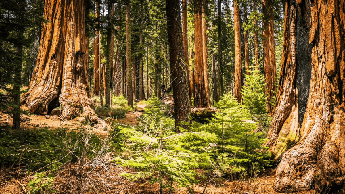
Not the kind of silence you get in an empty room — this one breathes. It hums. It hangs in the air beneath giants that have been here longer than most nations have existed. You’re in Sequoia National Park, where the trees are so wide they seem to hold up the sky, and time slows down the moment you step into their shadow.
Then the road curves. The forest gives way. And the world opens into a canyon — wide, wild, and echoing with wind. Kings Canyon is raw, elemental. Rivers rage through rock corridors, granite walls glow at golden hour, and every overlook pulls your breath a little further from your lungs.
These two parks — connected by more than a winding road — create a journey that feels less like tourism and more like returning to something ancient and true.
They are not rivals. They are a rhythm.
A balance of stillness and power.
A reminder of how small we are — and how beautiful that can be.
Most people visit both parks in one trip — and they should.
They’re managed as one, share a single entrance, and flow together in a way that feels completely natural. From giant trees to glacier-carved canyons, this route delivers one of the most moving national park experiences in the country.
In this guide, you’ll find:
- 🌄 The best hikes to feel that connection to the land
- 🛶 Hidden spots most visitors miss
- 🧠 Local tips to make your visit smoother, richer, and more meaningful
- 🌌 A bonus guided experience to turn a great trip into an unforgettable one
Whether you have two days or seven, the journey between giants and granite starts here.
🗓 When to Go & How to Plan Like the Parks Want You To
There’s a rhythm to Sequoia and Kings Canyon — and when you visit at the right time, it feels like the parks open up just for you.
In late spring, the snow begins to melt, feeding waterfalls and filling alpine lakes with crystal runoff. Wildflowers explode across the meadows, and the trails come back to life. This is when the parks begin to whisper again — not just “come visit,” but “come wander.”
By mid-summer, the full range of both parks is accessible. The Generals Highway connecting them is open, the nights are warm enough for stargazing, and long daylight hours stretch your adventure well past the golden hour.
Fall brings a quieter kind of beauty. The crowds thin, the air sharpens, and the light turns everything gold. Even the trees seem to exhale, and you’ll find entire trails to yourself if you go early.
Winter? It’s a different world — snowy, still, and sleeping. Portions of the park close, but the silence deepens. If solitude is what you’re chasing, it doesn’t get better than standing beneath snow-covered sequoias with nothing but your breath in the air.
🥾 Top 7 Hikes Across Sequoia & Kings Canyon National Parks
From peaceful forest walks to soul-shaking summit climbs — these are the trails you’ll remember.
📊 Trail Comparison Guide
| Trail Name | Location | Distance (Round Trip) | Difficulty | Why It Stays With You |
|---|---|---|---|---|
| Congress Trail | Sequoia NP | 2 miles | Easy | Silent walk among sequoia giants — poetic and grounding |
| Tokopah Falls | Sequoia NP | 3.8 miles | Easy–Mod | Granite-walled canyon ending in a roaring waterfall |
| Zumwalt Meadow Loop | Kings Canyon NP | 1.5 miles | Easy | Lush, quiet, almost surreal — perfect for a slow wander |
| Mist Falls Trail | Kings Canyon NP | 8 miles | Moderate | Forest, river, and raw waterfall power — a full-body reward |
| Big Baldy Ridge | Between both | 4.4 miles | Moderate | One of the best 360° views in the entire Sierra range |
| Alta Peak Trail | Sequoia NP | 13.6 miles | Hard | Massive alpine climb with insane panoramic views — not for beginners |
| Rae Lakes Loop (Section) | Kings Canyon NP | 17–40 miles | Hard | Backcountry epic with lakes, wildlife, and utter solitude — unforgettable for the brave |
✨ Whether you’re chasing serenity or sweat, these trails offer something deeper than just mileage. They’re paths that shift how you feel when you return to the world.
🌲 1. Congress Trail – A Cathedral Walk Among Giants
Location: Sequoia National Park
Distance: 2-mile loop
Difficulty: Easy
🌄 What You’ll See
This gentle loop starts at the General Sherman Tree, the largest living tree by volume. From there, the trail dips into the heart of the Giant Forest, weaving through towering sequoias, mossy clearings, and quiet groves like the “House” and “Senate” trees.
Unlike the quick photo stops near the parking area, the Congress Trail draws you deeper, into places where the trees stand like ancient monuments and the crowds fade behind the trunks.
🌿 What You’ll Feel
You’ll feel small in the best possible way.
The kind of small that reminds you the world is big, beautiful, and not always about you.
There’s a silence here — soft, sacred, and oddly comforting.
It’s hard not to slow your steps. Hard not to reach out and touch the bark.
You’ll breathe deeper. You might forget you’re in a national park.
You might just feel like you’re home.
🌟 Why This Trail Stays With You
It’s not about the distance — it’s about the presence.
You’re walking among living organisms older than the Roman Empire, still standing tall, still thriving.
For many travelers, this trail is where the trip truly begins. It sets the tone for everything that follows: wonder, awe, and respect.
🧭 Trail Tips
- Start early or late in the day for fewer crowds and golden light filtering through the trees.
- There are no major elevation changes, so it’s perfect for all skill levels and even kids.
- Bring layers, even in summer — the shade can cool you fast.
- Pause at the President Tree, a massive and often overlooked neighbor to Sherman.
- Walk quietly. You’ll hear birds, your own breath, and maybe — nothing at all. That’s rare.
💦 2. Tokopah Falls – The Canyon Walk With a Thunderous Finale
Location: Sequoia National Park
Distance: 3.8 miles (round trip)
Difficulty: Easy to Moderate
🌄 What You’ll See
The Tokopah Falls Trail begins behind the Lodgepole Campground and gently follows the Marble Fork of the Kaweah River through a canyon that feels more and more dramatic with every step.
Towering granite cliffs rise on both sides, snowmelt-fed streams cross the path, and eventually you’ll arrive at the base of Tokopah Falls — a stunning 1,200-foot cascade that tumbles in multiple tiers down a sheer rock face.
In early summer, the water is roaring. In late summer, it becomes a peaceful trickle — still worth the journey, especially for the alpine meadows and views along the way.
🌿 What You’ll Feel
This is a trail that invites wonder and reflection. The sound of the river becomes your rhythm. The canyon slowly narrows, and the sheer rock walls rise like a natural amphitheater around you.
The payoff — that moment when you round the final bend and the falls reveal themselves — is like a breath caught in your throat.
You’ll likely sit on a warm boulder, watch the water crash down, and not say much at all. That’s the beauty of it.
🌟 Why This Trail Stays With You
Because it’s unexpected.
Most people think Sequoia is all trees. This trail proves otherwise — wide-open sky, granite cliffs, wildflowers, marmots popping out of rocks, and a waterfall that makes the entire hike feel like a crescendo.
It’s also a great way to escape the crowds without committing to a strenuous day-long trek.
🧭 Trail Tips
- Go early in the day — both for parking and to see the falls in their best light.
- In May–June, expect fast-flowing water and possibly wet crossings — hiking shoes with grip are a must.
- This trail is not shaded, so bring a hat, sunscreen, and extra water.
- Watch for pikas and marmots near the boulder fields close to the falls.
- If you have time, linger by the river on the way back — some of the best photos happen when you’re not trying too hard.
🌾 3. Zumwalt Meadow Loop – Where the Canyon Whispers
Location: Kings Canyon National Park
Distance: 1.5 miles (loop)
Difficulty: Easy
🌄 What You’ll See
Tucked deep within Kings Canyon, far past the winding scenic byway, Zumwalt Meadow is a small loop with a massive emotional payoff.
The trail begins at a wooden footbridge over the Kings River, which runs crystal-clear and cold even in the summer months. From there, you’ll enter a serene landscape of open meadows framed by towering granite walls that look like they were pulled straight out of Yosemite.
You’ll walk across boardwalks, through pockets of shady pine forest, and along a rocky stretch that brings you close to the canyon wall — a perfect contrast to the lush green stillness of the meadow itself.
🌿 What You’ll Feel
Peace. Like the world took a deep breath and invited you to do the same.
This hike is slow by nature. It asks you to look around. To sit on a boulder near the river. To feel the breeze and listen to how quiet everything becomes when you stop moving.
It’s not dramatic like the falls or epic like the peaks — but it’s deeply calming, like a soft song that stays with you long after the last note fades.
🌟 Why This Trail Stays With You
Because it’s so different from everything else in the parks.
It’s flat. It’s accessible. And it’s utterly enchanting. You’re not climbing or chasing a summit — you’re just walking through beauty and letting it wash over you.
It’s the kind of place where you can imagine journaling. Or proposing. Or just sitting with your thoughts and remembering what silence sounds like.
🧭 Trail Tips
- The trail is short but uneven in places — part boardwalk, part rocky path. Take your time.
- Bring binoculars — Zumwalt is a great spot for birdwatching.
- In spring and early summer, the wildflowers are spectacular, and the river runs high.
- Midday light can be harsh — aim for early morning or golden hour to see the meadow glow.
- Consider bringing a small snack or thermos — there’s no better picnic bench than a warm rock beside the river.
💧 4. Mist Falls Trail – Into the Wild, Toward the Roar
Location: Kings Canyon National Park
Distance: 8 miles (round trip)
Difficulty: Moderate
🌄 What You’ll See
The trail to Mist Falls begins at Road’s End — literally the end of the scenic highway through Kings Canyon — and follows the South Fork of the Kings River into a dramatic, glacier-carved valley.
It starts in open forest and wildflower-strewn meadows, crosses rivers via footbridges, and runs parallel to rushing water almost the entire way. As you gain elevation, the granite walls close in around you.
Then the sound hits. You hear Mist Falls before you see it — a deafening, frothy cascade that crashes with such force it creates its own weather. On hot days, you’ll feel the cool spray long before you reach the overlook.
🌿 What You’ll Feel
Alive.
This hike builds. The quiet of the forest. The cool breeze through the canyon. The tension of the incline. And then — boom — the full sensory hit of the falls.
Your heartbeat syncs with the crash of the water. Your skin is wet with mist. And for a few minutes, nothing else matters.
It’s a full-body experience. And when you finally sit on a warm slab of granite overlooking the torrent below, you don’t think about your phone or your inbox. You just think, “This. This is why I came here.”
🌟 Why This Trail Stays With You
Because it’s a journey with momentum.
Mist Falls gives you what so many hikes promise but few deliver: rising anticipation, expanding views, and an ending that feels both physical and emotional. It’s raw nature at full volume, and it leaves a mark.
You may come back from this one tired — but you’ll also come back charged.
🧭 Trail Tips
- Go early — not just to beat the sun, but the crowds. This is a popular trail for a reason.
- Wear solid hiking shoes — there are rocky sections, and the spray zone can be slippery.
- Pack plenty of water and a light snack to enjoy at the top.
- The first 2 miles are flat, making this a good “go as far as you like” trail.
- If you keep hiking beyond the falls, the trail continues into truly remote wilderness — but only for experienced, well-prepared hikers.
🏔 5. Big Baldy Ridge – Quiet Trail, Endless Sky
Location: Between Sequoia & Kings Canyon
Distance: 4.4 miles (round trip)
Difficulty: Moderate
🌄 What You’ll See
This trail starts off unassuming — a dirt path through pine forest off the Generals Highway — but what it delivers by the end is nothing short of extraordinary.
After a gentle uphill walk through shaded woods and granite outcrops, you emerge onto a broad, bald granite dome with uninterrupted 360° views of the Sierra Nevada.
From the summit, on a clear day, you can spot the Great Western Divide, the San Joaquin Valley, and peaks that seem to stretch forever. And the best part? You might not be sharing it with anyone.
🌿 What You’ll Feel
Liberated.
Big Baldy gives you the gift of vastness without the pain of a punishing climb. There’s space up there — physical and mental — to breathe, to think, to just be.
And unlike more crowded viewpoints in the park, this one feels personal. Like you found it. Like it’s yours.
If you need a reset, this is where to get it.
🌟 Why This Trail Stays With You
Because it’s the perfect balance of effort and reward — enough of a climb to feel proud, but short enough to fit into a busy day.
It’s a trail that surprises you, both in its beauty and in how few people seem to know about it. One of the best-kept secrets in the park system.
🧭 Trail Tips
- Best hiked late afternoon or early evening for golden light and soft shadows over the Sierra.
- Bring a windbreaker — it can be breezy and exposed at the summit.
- Perfect spot for a trail snack or sunset photo session — just watch your footing on the granite.
- Trailhead is just off Generals Highway between Sequoia and Kings Canyon — easy to miss, so keep your eyes peeled for the small parking area.
🏞 6. Alta Peak – The Sky-Touching Trail for the Wild at Heart
Location: Sequoia National Park
Distance: 13.6 miles (round trip)
Difficulty: Hard
🌄 What You’ll See
Starting from the Wolverton trailhead, this route winds through lush pine forests, sunlit meadows, and sequoia groves before climbing above the tree line to a jaw-dropping summit at 11,204 feet.
You’ll pass Panther Gap (an incredible viewpoint in itself), continue through panoramic ridgelines, and finally scramble the last few rocky switchbacks to stand atop Alta Peak, where the entire Sierra Nevada unfolds below you — including views of the Great Western Divide, Kaweah Peaks, and even the edges of the High Sierra backcountry.
In early season, the trail cuts through snowfields. In late summer, the air is warm and crisp, and wildflowers cling stubbornly to the cliffs.
🌿 What You’ll Feel
Strength. Grit. Wonder.
This is a trail that pushes you — physically and mentally — and rewards you with absolute clarity at the summit.
The world below looks still. The sky above feels closer. And somewhere between breathless switchbacks and the summit wind, you realize you’ve let go of something heavy.
You didn’t just climb a mountain — you climbed back into yourself.
🌟 Why This Trail Stays With You
Because it demands everything — and gives you more in return.
Alta Peak is one of those hikes that becomes a memory marker in your life. Not everyone reaches the summit. But those who do never forget the view — or what it took to get there.
If you’re chasing a story you’ll tell for years, this is it.
🧭 Trail Tips
- Start early — this is a long trail with major elevation gain (over 4,000 feet).
- Bring layers — it’s chilly at the summit, even in summer.
- Pack a full day’s worth of snacks, electrolytes, and water (at least 3L).
- Hiking poles are a game-changer on the descent.
- Take your time — acclimate to the altitude and listen to your body.
- On the way back, stop at Panther Gap for one last quiet moment above the trees.
🏔 7. Rae Lakes Loop – The Trail That Changes You
Location: Kings Canyon National Park
Distance: 17 to 40+ miles (loop)
Difficulty: Hard (Multi-day, backcountry)
🌄 What You’ll See
Starting at Road’s End, the Rae Lakes Loop takes you deep into the High Sierra wilderness, weaving through alpine meadows, glacial lakes, pine forests, and high mountain passes.
The full loop includes Bubbs Creek Trail, a climb over Glen Pass (11,926 feet), and a series of spectacular glacial lakes — Rae Lakes themselves — which shimmer in deep blues and greens beneath craggy peaks.
You’ll cross rivers on backcountry bridges, pitch your tent under stars that don’t compete with city lights, and wake up to sunrise on still water.
Even a section hike (out-and-back to Rae Lakes) gives you access to landscapes that feel closer to Alaska than California.
🌿 What You’ll Feel
Freedom.
Rae Lakes isn’t just about elevation or scenery — it’s about isolation and simplicity. No service. No noise. Just the sound of boots on trail, wind in the pines, and your thoughts getting lighter by the mile.
You’ll feel challenged. Empowered. Wild.
And at some point, whether you’re filtering water from a stream or watching the last sunlight dance across a ridge, you’ll feel something rare:
Stillness.
🌟 Why This Trail Stays With You
Because it’s not just a trail — it’s a rite of passage.
Hiking Rae Lakes — whether the full loop or just a section — forces you to prepare, commit, and surrender to nature. It’s not for everyone, and that’s what makes it special.
If you want a trail that disconnects you from everything unimportant, this is where you go.
🧭 Trail Tips
- Permit required — reserve through Recreation.gov (they go fast).
- Ideal in late June through September, after snow melts but before early storms.
- Plan for 3–5 days, depending on your pace and route.
- Bring all the backcountry essentials: bear canister, water filter, layers, ultralight gear.
- Solo hikers should leave a trip plan with someone — it’s remote and wild out here.
- Best campsite: Arrowhead Lake or Rae Lakes themselves — absolutely unforgettable.
🛶 Hidden Gems in Sequoia & Kings Canyon Most Visitors Never See
These aren’t on the postcards — but they might be the moments you remember most.
📊 Hidden Spots Comparison Table
| Hidden Spot | Location | What Makes It Special | Vibe |
|---|---|---|---|
| Beetle Rock | Sequoia NP (near Giant Forest Museum) | Sunset views over the Sierra foothills | Peaceful, panoramic |
| Crescent Meadow Loop | Sequoia NP | Quiet forest loop with Tharp’s Log and bear sightings | Serene, storybook |
| Sheep Creek Cascade | Kings Canyon NP | Secret cascade just off a side trail | Refreshing, hidden |
| Moro Rock at Dawn | Sequoia NP | Iconic viewpoint — but empty before sunrise | Majestic, spiritual |
💡 These aren’t long hikes. They’re quiet detours, secret benches, and silent sunrises — places where the trip slows down and your memory speeds up.
🔎 Hidden Spots You’ll Wish You Knew About Sooner
🪨 1. Beetle Rock – The Place to Watch the World Exhale
Location: Sequoia National Park (behind Giant Forest Museum)
Distance: 0.3 miles (easy walk)
Best Time: Sunset
You won’t find it on most visitor maps, and that’s what makes it magical.
Just behind the Giant Forest Museum, a short forest path leads to a massive, sloping granite slab known as Beetle Rock. From here, the Sierra foothills roll out like ocean waves, catching the last light of day in amber and gold.
Kids love climbing on the rock. Couples sit quietly with thermoses of tea. Solo travelers stare out into silence and remember how to breathe.
💡 Bring a light jacket and a journal. The wind picks up near sunset, and this spot is made for still thoughts.
🌲 2. Crescent Meadow Loop – Where Bears Wander and Time Slows Down
Location: Sequoia National Park
Distance: 1.8-mile loop
Best Time: Early morning or late afternoon
John Muir called it the “Gem of the Sierra”, and he wasn’t exaggerating.
This flat, quiet trail loops around a lush meadow fringed by towering sequoias, where you’re more likely to see a black bear or deer than another hiker.
It’s also home to Tharp’s Log, a 19th-century pioneer’s cabin literally carved into a fallen sequoia — part folklore, part fairytale.
The light here is soft. The trail is calm. And the silence feels like it’s whispering something you forgot you needed to hear.
💡 Look closely for animal tracks in the mud near the creek. And if you see a bear? Stay still. Smile. Soak it in.
💧 3. Sheep Creek Cascade – The Secret Spot You’ll Want to Keep to Yourself
Location: Kings Canyon National Park
Distance: Short detour off the main trail
Best Time: Midday for sparkle; morning for solitude
Somewhere off a quiet bend along the Sheep Creek trail, you’ll hear it — water tumbling over rocks. Follow the sound. There’s no sign, no crowd, and no guarantee it’s running full unless the snow’s been generous.
But when it is? This hidden cascade spills through mossy granite, creating a cool, fern-lined pocket that feels entirely your own.
💡 Sit on the sun-warmed rocks nearby and dip your feet in the stream. It’s a perfect reset after any hike — especially Mist Falls or Road’s End.
🌄 4. Moro Rock at Dawn – Where the Sierra Greets the Sun Alone
Location: Sequoia National Park
Distance: 0.6 miles (with stairs)
Best Time: Sunrise — 100%
Most people visit Moro Rock at mid-morning or golden hour, when the small stone staircase is packed with selfies and nervous climbers.
But if you go before sunrise — flashlight in hand, breath fogging in the cold — you’ll have the entire summit to yourself.
As the first light creeps over the Great Western Divide, painting the clouds pink and the valleys gold, you’ll understand why it was worth the early alarm.
💡 Bring a headlamp, a warm drink, and someone you love — or no one at all.
🧠 Local Wisdom: What Rangers, Guides & Lifelong Visitors Want You to Know
Because how you explore matters just as much as where you go.
🕐 1. Go Earlier Than You Think You Need To
That trailhead that’s empty at 7:30 a.m.? Full by 9.
Rangers often say:
“If you want to find the park’s voice, be there before the cars start talking.”
Mornings are sacred here. The light is softer. Wildlife is more active. And the silence hasn’t been broken yet. Especially in places like Crescent Meadow or Mist Falls, starting early turns a great hike into a spiritual one.
🗺 2. Don’t Just Bring a Map. Learn to Read the Land
Cell signal is a fantasy in most of the parks — and honestly, that’s a gift.
Before you go, download offline maps, but also look at the terrain, understand elevation, trail junctions, and water sources. It’s not just safety — it’s connection.
“The more you understand the land, the more it starts to feel like it knows you too.”
🌲 3. Slow Down and Let the Parks Set the Pace
So many visitors rush from Sherman Tree → Moro Rock → Grant Grove like they’re checking off boxes.
But these aren’t amusement parks. These are ancient, living places.
Take the long way. Linger by the river. Sit under a tree for longer than feels efficient.
“Some of the best parts of a hike are the parts where you don’t move at all.”
🧴 4. Sunscreen, Layers & Water Are Non-Negotiable
Kings Canyon can be 90°F and exposed. Sequoia can be 40°F and shady — on the same day. Weather swings fast, especially at elevation.
Bring:
- A wide-brimmed hat
- A breathable long sleeve
- More water than you think you’ll drink
“Trail regret usually starts with ‘I thought I didn’t need…’”
🔇 5. Let the Quiet Happen
Put the phone away. Don’t bring speakers. Don’t narrate every moment for social media.
You came to Sequoia and Kings Canyon for something bigger than noise. Let the quiet do its work. It will speak louder than any playlist.
“You’ll remember the silence longer than any photo.”
🪵 6. Respect the Trail as a Living Thing
Stay on the trail — even if the shortcut looks easier.
Trampling meadows or cutting switchbacks might not seem like much, but these ecosystems are fragile. And old. Some of the moss under your boots might be older than you.
“Tread softly. You’re walking on something sacred.”
🐻 7. Learn the Difference Between Wild and Dangerous
Seeing a bear is magical. So is hearing coyotes at dusk or spotting a rattlesnake sunning on granite. These parks are alive — and not here to be tamed.
Keep your distance. Store food properly. Watch, don’t interfere.
“When you meet the wild with respect, it often meets you back with awe.”
🪞 8. Don’t Try to Do It All. Try to Feel It Fully
You won’t see every grove or hike every canyon. But if you slow down enough to feel one moment deeply — a sunset at Zumwalt Meadow, a whisper under the sequoias — that will stay with you longer than any checklist.
“You came to remember something. Give it space to find you.”
🛠 9. The Real Gear You Need Isn’t on Your Back
Yes, bring the right shoes and water. But also bring curiosity, patience, humility. These parks don’t just reward strength — they reward presence.
“The best thing to pack is the version of yourself that’s willing to listen.”
🌌 One Guided Experience That Turns a Great Trip Into an Unforgettable One
Because sometimes, letting someone else lead the way is exactly what you need.
You’ve read the maps. You’ve picked your trails. You’re ready to chase big trees and canyon light.
But maybe you want something more personal.
Something that lets you leave the logistics behind — and focus fully on the feeling of being there.
If you’re short on time, new to hiking, or simply want a day where everything is taken care of, consider this:
🎒 A private guided hiking tour in Sequoia National Park — where a local expert leads you through some of the park’s most breathtaking terrain, at your pace, with stories, context, and care.
You won’t be in a crowd. You won’t be rushed.
You’ll walk through the giant forest with someone who knows where to pause, where to look up, and where the sunlight hits just right in the afternoon.
You’ll get safety, knowledge, and presence — all wrapped into one powerful day.
→ Click here to check out the guided experience
“Sometimes the best adventure begins when you stop leading and start listening.”
🌲 Final Thoughts – Go Gently, Go Deep, and Let the Parks Work on You
Sequoia and Kings Canyon aren’t just places to visit — they’re places to return to, even if only in memory.
Maybe it’s the light through the trees.
Maybe it’s the sound of water echoing off granite.
Maybe it’s just the space — the kind that’s hard to find in the rest of the world.
Whatever it is, when you go, go with your eyes open and your heart a little more quiet.
You don’t have to conquer every trail. You just have to be there fully — for one of them.
And maybe that’s enough to carry something home that lasts longer than photos.
Disclaimer: This post contains affiliate links. If you click and make a purchase, we may earn a small commission — at no extra cost to you. Every recommendation is chosen with care to help you plan better, travel deeper, and support the work we do here.
© Copyright 2025 chasethebigdream.com. All rights reserved.